Coconino County, Arizona, June 2010

Go to the Home Page


In late June I visited Flagstaff. The Schultz Fire had started several days earlier and burned much of the east side of San Francisco Peaks. I explored the forest roads leading south to overlooks of the West Fork of Oak Creek Canyon and the Red Rock Secret Wilderness.

June 25, 2010

Red Rock Secret Wilderness Overlook 
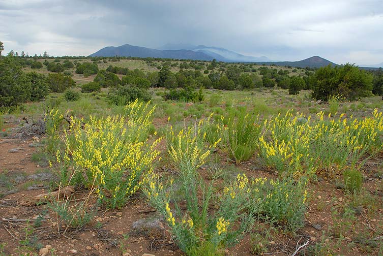
Yellow Lupines bloom as smoke wafts from the Shultz Fire five days after it started burning in the San Francisco Peaks.

San Francisco Peaks and Shultz Fire

Panorama size: 347 megapixels (21422 x 16231 pixels)
Input images: 110 (10 columns by 11 rows)
Field of view: 108.5 degrees wide by 82.2 degrees high (top=30.1, bottom=-52.0)

San Francisco Peaks and Shultz Fire, June 25, 2010 Panorama shot with a Gigapan robotic camer mount near Walnut Canyon.

Art Prints You can buy prints up to four feet by six feet or greeting cards of this photograph.

West Fork of Oak Creek Canyon from East Buzzard Point

Panorama size: 1051 megapixels (45210 x 23257 pixels)
Input images: 352 (22 columns by 16 rows)
Field of view: 228.9 degrees wide by 117.7 degrees high (top=62.3, bottom=-55.4)

West Fork of Oak Creek Canyon from East Buzzard Point, June 25, 2010 Looking down into the west fork of Oak Creek Canyon from East Buzzard Point.

Red Rock Secret Wilderness Overlook Wilson Mountain and the Red Rock Secret Wilderness.

Red Rock Secret Wilderness Overlook

Red Rock Secret Wilderness Overlook

Red Rock Secret Wilderness Overlook

Looking down into Red Rock Secret Wilderness. The city of Sedona lies on the far side of Capitol Butte in the distance. Smoke from the Shultz Fire obscures the distant horizon.

Panorama size: 742 megapixels (28789 x 25785 pixels)
Input images: 234 (13 columns by 18 rows)
Field of view: 145.7 degrees wide by 130.5 degrees high (top=75.8, bottom=-54.7)

Red Rock Secret Wilderness Overlook, June 25, 2010

Art Prints You can buy prints up to four feet by six feet or greeting cards of this photograph.

Red Rock Secret Wilderness Overlook

Red Rock Secret Wilderness Overlook

Red Rock Secret Wilderness Overlook

Red Rock Secret Wilderness Overlook

Red Rock Secret Wilderness Overlook San Francisco Peaks

Red Rock Secret Wilderness Overlook

June 27, 2010

Red Rock Secret Wilderness Overlook The Schultz Fire burned across Highqway 89 and reached Bonita Park near Sunset Crater.

Red Rock Secret Wilderness Overlook Bonita Park

Red Rock Secret Wilderness Overlook The Schultz Fire was still burning on the lower slopes of Fremont Peak.

Red Rock Secret Wilderness Overlook Most of Sugarloaf Peak burned.

Red Rock Secret Wilderness Overlook Sunset Crater

June 28, 2010

Red Rock Secret Wilderness Overlook The Red Rock Secret Wilderness. Sedona lies on the far side of Capitol Butte. The Verde Valley is in the far distance.

Red Rock Secret Wilderness Overlook, June 28, 2010

Looking down into Red Rock Secret Wilderness. The city of Sedona lies on the far side of Capitol Butte in the distance. Smoke from the Shultz Fire obscures the distant horizon.

Panorama size: 758 megapixels (29397 x 25802 pixels)
Input images: 252 (14 columns by 18 rows)
Field of view: 124.1 degrees wide by 108.9 degrees high (top=49.5, bottom=-59.4)

Red Rock Secret Wilderness Overlook, June 28, 2010 Panorama shot with a Gigapan.

Art Prints You can buy prints up to four feet by six feet or greeting cards of this photograph.

Red Rock Secret Wilderness Overlook Capitol Butte

Red Rock Secret Wilderness Overlook

Red Rock Secret Wilderness Overlook

Red Rock Secret Wilderness Overlook

Red Rock Secret Wilderness Overlook

Red Rock Secret Wilderness Overlook

Red Rock Secret Wilderness Overlook

Red Rock Secret Wilderness Overlook

Red Rock Secret Wilderness Overlook

Red Rock Secret Wilderness Overlook

Red Rock Secret Wilderness Overlook

Looking down into Red Rock Secret Wilderness. The city of Sedona lies on the far side of Capitol Butte in the distance. Smoke from the Shultz Fire obscures the distant horizon.

Panorama size: 871 megapixels (33643 x 25898 pixels)
Input images: 288 (16 columns by 18 rows)
Field of view: 171.1 degrees wide by 131.7 degrees high (top=71.0, bottom=-60.7)

Red Rock Secret Wilderness Overlook, June 28, 2010 Panorama shot with a Gigapan.

Art Prints You can buy prints up to four feet by six feet or greeting cards of this photograph.

Skies Over Flagstaff, Arizona May - June 2010

Time lapse movies of sunrises, sunsets, cumulus clouds, and smoke from wildfires around Flagstaff, Arizona. The 89 Mesa Fire and the Shultz Fire generated plumes of smoke that drifted with the wind. Moist air flowing through the area creates cumulus clouds as it rises over sources of heat and mountains.


Go to the Home PageSend a message to Brian.